7 Favourite Hikes in the Rockies

Some things to note:
— As of 2023, the road to Moraine Lake (in which a few of these hikes start on) is closed to private vehicles, with access being only to shuttles and commercial buses. Do plan accordingly if you want to get to these places for sunrise/sunset.
— In summer, the later you head out, the less chance there is for a car park even on hikes not based in popular hotspots like Lake Louise.
— It can get crowded on the popular hikes like Lake Agnes. But don’t let that deter you - the hikes are always worth it!
Minestimma Lake
Difficulty: Moderate
Roundtrip Distance: 8.9km
Elevation Gain: 697m
Route Type: Out & Back
Notes:
This hike has so much to offer (alpine views above Canada’s most famous lake, elevation, reflection AND larches in the fall) making this one of the most beautiful hikes in the Rockies! Note the trail does follow the same track as the Larch Valley hike and is extra busy in the months of September and October.
The track itself starts from the lakeshore path of Moraine Lake, branching to the right. You’ll ascend 2.4kms on 11 switchbacks (yes, I counted them!), gaining higher and higher views of Moraine Lake below. The trail then heads into the larch forest, gilded in gold in the fall, with numerous spots to stop for pictures or to take a break. Slowly, the view opens up, offering a panorama of the Ten Peaks range and Larch Valley below. Further up the track and laying on the foot of Sentinel Pass lies Minestimma Lake - a small body of water provides a majestic scene, reflecting the Ten Peaks on calm waters (if you’re lucky!).
Photography Tips:
Well before dawn is the best time to hike up this trail hands down, aiming to be at the lake just before sunrise. Early morning offers the best conditions to photograph the reflection of the peaks on the lake, as chances are better for less wind and calmer waters. Be prepared with a tripod or know the settings of your camera well to capture the golden light hitting the peaks as these fiery fleeting moments will take your breath away.


Consolation Lakes
Difficulty: Easy
Roundtrip Distance: 7.4km
Elevation Gain: 323m
Route Type: Out & Back
Notes:
Low effort, high reward is what makes this hike such a favourable one. There’s also a real sense of wild and connection to nature out here, paired with peace & quiet compared to nearby Moraine Lake. The trail begins on the path heading towards Moraine’s famous Rockpile. Take the path to the left (indicated with a pointer to Consolation Lakes at the junction + a sign about bear safety). Path is rocky, with uneven terrain at the start and wanders into the forest. Ascending for a few kms in the woods next to a stream, you’ll reach a wooden boardwalk about 3/4 of the way with excellent views of the mountain in front. The trail soon opens up into a stunning lush valley with a babbling brook right next to the meadow. If you’re hiking in midday, this is the perfect spot for lunch or a little dip in the water! To get to the lake however, continue on and traverse through big rocks, watching your step here as some of them can be a little wobbly! Don’t forget to keep your eyes peeled for marmots and pikas.
Photography Tips:
To capture the majestic scale of the lake, bring a wide angle lens and play around with the perspective. There’s a lot of space (and rocks!) to roam around and get a different view. I find that this lake is quite good for reflections perhaps due to the surrounding mountains hindering the wind. If you want to get a better reflection of the mountains with more detail, aim to be there when the sun is low so the shadows shine through — but be prepared with bear spray and torches for the walk back in the dark. Don’t be THAT person that gets themselves in dangerous situations!


Plain of Six Glaciers + Teahouse
Difficulty: Moderate to Hard
Roundtrip Distance: 14.6km
Elevation Gain: 588m
Route Type: Out & Back
Notes:
It’s funny that the most famous lakes in Canada are so close to some of its most beautiful hikes too. The Plain of Six Glaciers has it all - sweeping valleys, rocky ridges, picturesque lookout points and the best teahouse. You feel a lot closer to nature and the wild on this hike because it’s more for intermediate hikers and thus less touristy. It is located towards the far end of Lake Louise, standing on the shores you can see the glacier right in front of you but they are actually quite far out and huge! The trail starts at the Lake Louise lakeshore, passing the signs to Little and Big Beehives and walking some flat 2km around the lake. The further you go, the quieter it gets. You’ll pass a popular rock-climbing spot (take a moment to gaze up at climbers suspended in space) and continue into a forest. The next few kms of hiking will involve passing ridges and crevices above the treeline - keep an eye out for Pikas- until you hit a set of steep switchbacks that are directly below the teahouse.
One of the highlights of this hike is the beautiful and quaint Plain of Six Glaciers Teahouse, a seasonal teahouse preserved in its original form with no electricity. Much quieter than its sister (the Lake Agnes Teahouse), it is open during the spring & summer months where hikers can enjoy a menu of light lunches, desserts and teas! You’re not allowed to bring your own food to eat in the hut - as it’s reserved for patrons only. I recommend the Vegetable Curry and their jam and butter scones - there’s something so special about eating such hearty food in the backcountry..
After a little lunch, and to see the glaciers up close, continue 1.5km on to Abbots Pass Viewpoint (although it actually is the end of the Plain of Six Glacier Hike). This part of the hike is a little more challenging. You’ll traverse through a very narrow glacial moraine, watching your step as you hike up until you reach a scree slope at the end that faces the pass and the glaciers.
Photography Tips:
The Plain of Six Glaciers hike actually doesn’t offer much in terms of colour. There’s a neutral palette of greys, beiges and white especially on a cloudy day. However this makes it easier for a subject to pop out in an image - just take a brightly coloured jacket! Also keep an eye out for avalanches as they make great motion shots - put the burst shooting mode on by the teahouse and get ready to capture it.


The Teahouse about 3/4 of the way

Looking back on the trail, with the Fairmont Chateau in the distance

Great, well-maintained trail conditions

Avalanches are quite common to hear - like a loud thunderous clap!

Lake Chephren
Difficulty: Easy
Roundtrip Distance: 8km
Elevation Gain: 243m
Route Type: Out & Back
Notes:
This hike is full of roots and uneven terrain and can be quite slippery/muddy in the spring season - I recommend late summer for this one. Another low effort, high reward hike, Chephren Lake is one of those hidden gems. I came across it on the Alltrails app and was immediately enamoured! This lesser-visited glacial lake is tucked deep in the forest behind the Waterfowl Lakes Campground. The trailhead starts just past the campground, where you cross a wooden bridge over the Misty River. The trail goes into the forest as you very gradually ascend, passing a few simple wooden boardwalks, a couple of gorgeous meadows and lots of views of Howse Peak and Mount Chephren above. The path then descends towards the lakeshore, with lots of rocks and a few boulders to perch and watch the morning sun, hopefully with the lake all to yourself.
Photography Tips:
I’ve seen photos of the lake in midday and can safely say that it’s best to visit early morning or later in the afternoon for stiller waters and better reflections. Use scale to create an idea of how grand this place is. In the image below, I used my friend Misa to show how big the lake and the mountains behind actually were. Big bonus if you coordinate your outfit with colours that go well with the lake’s turquoise, emeralds and blues!


Little Beehive
Difficulty: Moderate
Roundtrip Distance: 9km
Elevation Gain: 535m
Route Type: Out & Back
Notes:
The most popular hike on this list, the Little Beehive is on the same trail to other well-known spots such as Mirror Lake, Lake Agnes + it’s teahouse and the Big Beehive, so naturally it will have a lot of people travelling in the same direction as you. In the height of summer, there will be a LOT of people doing this trail but please don’t be deterred - it’s world-renowned for a reason! The best time to enjoy this hike is starting early in the morning or late in the afternoon into the evening when there are fewer visitors around. If you can’t find any parking at the Lake Louise Carpark, just head down to the village and take a bus up.
With stunning panorama views of Lake Louise below, the Fairmont Chateau to the left and Victoria Glacier to the right, this lookout is a must. From the lakeshore you’ll come across a sign on the right pointing to the start of the Little Beehive hike, where you’ll ascend through the forest, catching glimpses of Lake Louise in between the trees. There will be a turn on the switchback with the perfect shot of the waters and Mount Fairview behind it so don’t forget to stop and enjoy the view.
Continue on and see Mirror Lake, where the Big Beehive is reflected on. A little further up and you’ll reach Lake Agnes and its teahouse. Take in the views of the Big Beehive, Mount Whyte, Mount Niblock, and Mount St. Piran from the historic teahouse that has been standing since 1901. The teahouse can have long line but it’s definitely a worthwhile experience (when we arrived at 8am, there was already a queue!). After reaching the teahouse, you’ll head on to the path behind it, where the crowd thins out, climbing up once more. Eventually you’ll find yourself atop Little Beehive, enjoying scenic views with only a mere few others or perhaps by yourselves and a few squirrels.
Photography Tips:
Bring along a CPL filter (polarising lens filter) with you to cut the glare on reflected surfaces! I also recommend bringing a zoom lens something with 100mm or higher to get some good detail shots of the glaciers or the misty scenes from afar. There is a rock pile before the end of the Little Beehive that is perfect for taking photos on but watch your step! It’s not worth endangering your life for a gram shot.


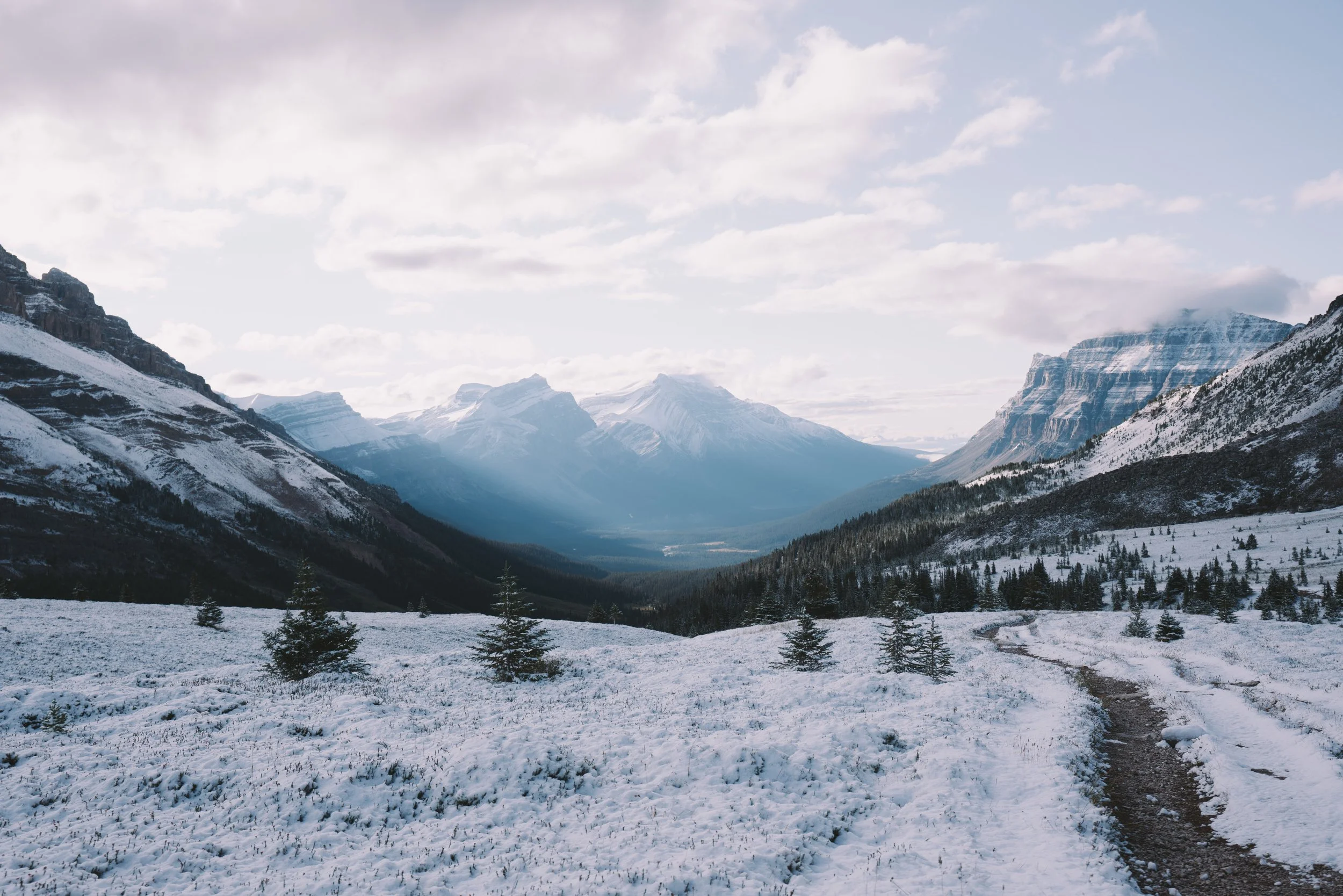
Helen Lake
Difficulty: Moderate to Hard
Roundtrip Distance: 11.6km
Elevation Gain: 540m
Route Type: Out & Back
Notes:
This is one of those hikes where the journey is more beautiful than the destination. This trail is known to be quite popular in July for wildflowers however I did this hike in early September, starting in the very wee hours of the morning. Located off the Icefields Parkway, this track starts as a steady incline through the forest, careful as you tread through tree roots, rocks and a few creeks. After about 4.5km, you’ll reach a series of switchbacks that run along for about 2km. About halfway to the lake and at the top, the trail opens up onto a ridge overlooking the valley, where you’ll be walking parallel to some very majestic mountains. When I visited there was a fresh dusting of snow overnight that really made the whole scene surreal. 2km further and you’ll be reaching the famous meadow. Unfortunately for us it was too late in the season (although I plan to hike this trail again this year!) and there were no flowers, but the snow still made it very beautiful. You’ll eventually reach Helen Lake at the foot of Dolomite Pass, a good place to stop for a bite to eat on a rock.
Photography Tips:
There is a bridge just before the alpine meadow that is placed perfectly for a beautiful landscape composition - a post-card picture perfect view, complete with running creek in the middle, wooden minimal bridge and mountain ridges behind. Run around to frame your shot and take your time!


Arnica Lake
Difficulty: Hard
Roundtrip Distance: 9.3km
Elevation Gain: 758m
Route Type: Out & Back
Notes:
Quite the trail, this hike is another gem for the autumn season. The Arnica Lake Hike is an extension of another trail called Vista Lake. The entrance to the trail is located on the Banff-Windmere Parkway, 8 minutes away from the Trans-Canada highway. In the summer season, the parking lot fills up fast, so I recommend heading early for this hike!
Just after the trek down to Vista Lake, you’ll be winding up through forest areas, crossing multiple creeks and waterfalls and eventually reach the larches! At peak season, the larches can be seen all over the ridges, on top of the ranges and skirting Arnica Lake shores. Watching the sunrise hit the mountains and enveloping the larches in fiery golden hues is something quite special. Keep an eye out for a special alpine meadow enclosed with trees that looks up to the mountain - it’s perfect for taking a rest and snapping a few photos. With steep ups and downs, and most of the elevation gain done on switchbacks, this is definitely a more moderate hike.


I hope this was helpful in helping you plan your own Rockies adventures! Leave a comment if there’s anything I’ve missed or thoughts you want to share!
x M